


Our Seafield Mural on That’s TV
A 3 minute video for That’s TV featured our new Seafield Mural. Find out more about the project here: https://www.facebook.com/thatstvscotlandeast/videos/342530553069230/

Get your free shoreline activity pack!
We’re delighted to be able to offer schools, families and community groups a free shoreline activity pack. It’s bursting with ideas on events and projects that you can undertake in your local area to celebrate and preserve the history and wildlife that is so important to the Edinburgh shoreline! Find ideas on activities like conducting your own beach clean or creating a wildlife garden, and many more. This resource is suitable for groups of all ages. You can download a digital copy by clicking here: Shoreline community ideas pack We also have paper copies of the pack in a ring binder for your group to use. Please contact the Edinburgh Shoreline Project Manager Charlotte Johnson on cjohnson@rbge.org.uk to request a copy. We’d love to know how you get on using the pack and to see photos of your endeavours. Please send them to Charlotte using the contact details above. Once again,...
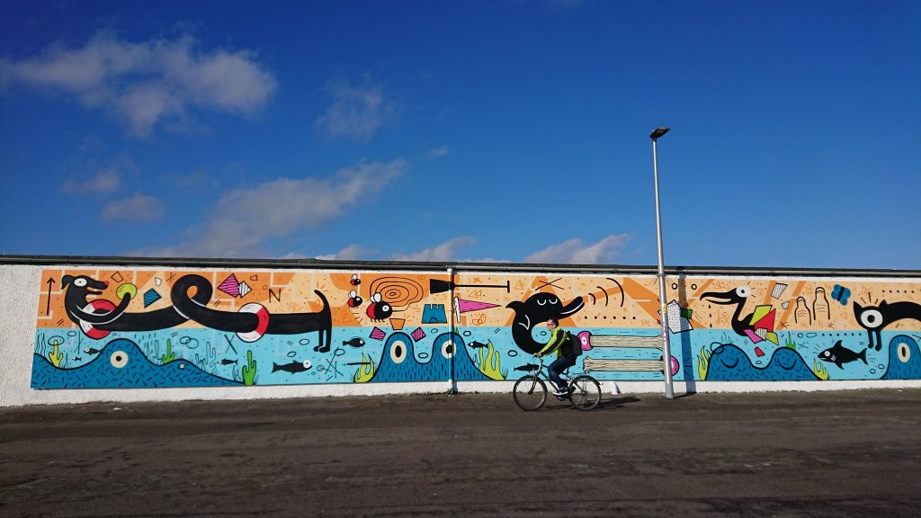
Seafield Prom mural unveiled
We are over the moon to launch a new mural at Seafield Prom in collaboration with Edinburgh Dog and Cat Home, artists Katie and Emma of Studio N_Name and local residents. Many thanks to Talk Porty for allowing us to use their photograph, taken in the sunshine on Thursday morning! In Spring last year the Edinburgh Shoreline project hosted a walk along Seafield Prom to look at the plant species present there, and to plan to plant up some areas of amenity grassland with Scottish wildflowers to improve the space for people and wildlife. The walk was attended by lots of interested members of the public and some staff from Edinburgh Dog and Cat Home. While on the walk many people commented on the graffiti on the walls along the prom and the fact that the area was quite unpleasant on the eye, despite the fact that it’s a heavily used...

Edinburgh Shoreline documentary short version
We’ve had fantastic feedback about our project documentary, which charts what we’ve been getting up to in our first year and people’s thoughts on our coastline. Some folk have asked if there is a shorter version that they can show to their community group, friends or neighbours and we’re pleased to be able to share this shorter version with you! https://youtu.be/DtBESZI5o5s If you have any questions or want to discuss screening the film somewhere then please get in contact with our Project Manager Charlotte Johnson on cjohnson@rbge.org.uk

Edinburgh Shoreline project has reached Glasgow!
A few weeks ago Dr Larissa Naylor from the University of Glasgow joined us for our 1st anniversary celebration, taking part in our discussion panel. As a token of our appreciation we gifted Larissa a packet of wildflower seeds – thrift, to be exact. Thrift, or armeria maritima, with its beautiful pink flowers loves to grow by the sea; sea cliffs, saltmarshes and dunes are some of it’s favourite places. We were delighted to receive an email a week later to say that Larissa’s two young children wanted to grow the thrift with their nursery classes. Cue some excellent photos of wee ones getting stuck in to some seed sowing! They’ll now be tending them with care and consideration for the coming few weeks. Once the seeds have germinated and grown into substantial seedlings they’ll be sending them back to us so that we can use them with community groups who...

Japanese rose removal at Cramond
We recently joined forces with the City of Edinburgh Council to do some removal of an Invasive Non-Native Species plant at Cramond sand dunes. Japanese rose, rosa rugosa, was introduced to Britain in the 18th century as a plant for formal gardens. It has since spread and can often be found in coastal areas. It sends out long underground rhizomes to spread, which form a dense network which destabilises the sand dune and is hard to remove. It out-competes other native species. As such, the City of Edinburgh Council runs a programme of removal, and we joined them to help with removal at Cramond. Many thanks to all the volunteers who came along for our two-day session in the (mainly) sunshine. Passers-by might have noticed 3 exclusion zones fenced off on the Cramond sand dunes. These areas have had the natural grasses and plants worn away as people have walked across...
Edinburgh shoreline memories
Over the last 6 months filmmaker Sitar Rose has been travelling along our shoreline collecting memories of times gone-by. She has interviewed local residents about their memories of growing up in the area – on life, work and recreation on the coast. We’re delighted to be able to share these films with you. Just follow the links to hear each of the stories on our YouTube channel: Ella – Living in Newhaven and Granton George – Childhood in Newhaven Janis – Portobello memories John D – Living and working in Granton Jim – Changing Leith John H – Newhaven stories Tom – On the lifeboats

Shoreline GIS data
The Edinburgh Shoreline team recently visited the Central Scotland Green Network Trust to view a map they had pulled together of lots of different types of data which related to our shoreline; the map showed locations of hard sea defences, different habitats both natural and man made, access points to green space, active travel routes and more. All of the data is currently available to the public in various places, but they had pulled it together into one place! What a fantastic resource! On Thursday 21st March we held a Green Tease event, led by our friends at Creative Carbon Scotland, to look at the map and think about how we might use it to identify areas of opportunity on our coastline. For example, we looked at all of the green spaces near to the coast, such an abundance of little pockets! We discussed ways in which we could potentially...
The Edinburgh Shoreline project is 1!
How time flies when you’re having fun! On Saturday 2nd March we held a celebration event to mark the first anniversary of the project. At the event we launched our project documentary, community map and oral history interviews. Many thanks for the 100 people who came along and helped to make it such an enjoyable day. Our documentary film, which charts what we have been up to over the last year, as well as local people’s vision for the future of our shoreline, was very well received. We are delighted to be able to share it with you now! Just follow the link to see why the Edinburgh shoreline is so special: https://youtu.be/i4G8jqpgu70 Our sincerest thanks go to both René Sommer Lindsay, who gave an interesting talk on how Copenhagen is adapting to climate change, and Emily O’Brien, who spoke about the work of Seafield Shoreline who are improving planting and...
Artecology on BBC’s Countryfile
We hope you were all watching Countryfile last night and spotted Artecology’s vertipools! Here’s a handy link if not (minute 27-34): https://www.bbc.co.uk/iplayer/episode/b0bvgw3r/countryfile-isle-of-wight?fbclid=IwAR0wKaQJAzloqnxnuPD5Uda8eckE8D6Gw2leub-7GfbhajSlGamg3oqW7PY Did you know that in the pilot stage of the Edinburgh Shoreline project we (along with Artecology, Concrete in the Classroom, Scottish Wildlife Trust, Edinburgh School of Architecture and Landscape Architecture and local schools) installed some vertipools and biodiversity tiles on the sea defences at Cramond? We’ve also been developing some more tiles with Craigroyston High and Leith Academy in September of this year. Find out more here: https://edinburghlivinglandscape.org.uk/project/grey-to-green/?fbclid=IwAR1CrXYg3qD9U1KT0u_dudkD-Jt08LiOfwgleV-wHbcrbgLy4ecThTsZPFs An artificial rockpool installed on the sea defences at Cramond on the Firth of Forth as part of the Concrete in the Classroom project. Front Larissa Naylor (Lecturer in Physical Science Glasgow Uni) rear Leonie ALEXANDER (RBGE Urban Biodiversity Project. Images courtesy of Lorne Gill, Scottish Natural Heritage.